
I first learned of Street-Complete here and I really like it.
It’s satisfying to walk around, complete little tasks, and get prizes, scratching a similar itch to Pokemon Go.
Stuck waiting for someone? Add opening hours for a few local businesses.
Have a long walk ahead of you? See if you can add/check house addresses as fast as you can walk.
Want to walk off a few beers before heading home? Complete some tasks in the bar street.
Its a very constructive way to “be right” on the internet.
Can I throw in that once you get your stride with Streetcomplete you’ll love Every Door where you can add Shops and features pretty easily. They really complement each other.
@abeorch @vatlark Also have a look at https://mapcomplete.org
Im also interested in Mangrove Reviews. Have to find more out about that.
The thing I like about mapcomplete is the ability to add photos and reviews for Bars and restaurants. that’s really good.
I find each application has its niche and I switch between them depending whether Im walking around or filling.in details.
Thank you for the tip. Installed.
Ta add another one: StreetMeasure. But I think that will be suggested in SC if you don’t have it installed?
Yes … StreetMeaure is very useful - Though I’d prefer it to be available from F-droid - I wonder why its not? Same developer right?
I looked it up in F-Droid. It is only available in the IzzyOnDroid repo. StreetMeasure relies on ARCode and the Google Play Services for AR, so it is against F-Droids inclusion policy.
i wondered something like that. Its a useful tool Obviously prefer not to be using Google Play Services but compromise makes the world go round. Better that than using Google Maps all the time.
Fdroid says that it is bound to jawg.io for tiles. What are the chances that we are giving our data to a company who will take it away from us, or is just using us for free labour?
It is free labor. However it benefits us all and there isn’t any alternatives. I don’t think OSM is going anywhere soon. It is has benefits for any people and industries.
Fun fact OSM has had lots of issues with hostile take overs. They now have a dedicated committee on the subject https://osmfoundation.org/wiki/Special_Committee_on_Takeover_Protection
or is just using us for free labour?
It pushes updates to openstreetmap.
@jaxxed @vatlark @openstreetmap
Very slim. But their privacy policies are online if you’re concerned.You free labour all goes to the OpenStreetMap database licensed under the Open DataBase License.
Yes, you link your OSM account to StreetComplete and it adds your contributions via your OSM account. Same with Vespucci.
When you log into OSM you can see all the contributions pushed by StreetComplete.
I love this app so much, also if you really get into it go to the open street map website and draw buildings, roads, etc to add missing places or update changes.
I cleared my whole walkable area of questions then added all the houses and it populates new questions about house number, shop name, etc which I then went and filled out while walking round. In the zone around me the open source map is now by far the best free to access map, Google house numbers are completely random and no where has upto data shops.
There’s also a lot of cool projects devoted to mapping under-served areas, especially in regions where aid workers need information or natural disasters have changed landscapes. You draw in roads, towns, farms, etc based on areal imagery.
StreetComplete to the polls
iOS version is in the works but there’s something similiar online too.
I’ll recommend this to my wife who plays Pikmin Go religiously.
@MonkderDritte @vatlark @openstreetmap
@MapComplete is only similar in that it is aimed at giving simple tailored forms to new users. It does not make it easy to contribute “all the low hanging fruit closest to me”.
Thanks a lot for the suggestion, it’s quite fun and I’d love a future where OpenStreetMap data is exaustive
It already is better than Google in some areas. For instance, it has way more information on hiking trails.
Pretty sure they’re used for RideGPS, too.
While StreetComplete is very careful with the quests, my experience with SCEE was much worse. As an example, with current SCEE 58.2 the building color quest is still buggy. The brown, black and white choices are showing wrong colored illustrations.
Therefore SCEE is not a recommendation for me.
@redd @Andromxda Did you mention this on GitHub? That should be solvable.
This is the most fun app in the world. I hope they keep building on top of this, it’s amazing! Plus, being able to see new “quests” popup as you edit on OSM/edit? Amazing!!
If there was some way for the app to create teams trying to fill out details like in Pokemon Go, that would be crazy exciting. Would be difficult to balance that so it didn’t incentivize adding junk… Maybe having a third party keeping players in check? Not sure, but the possibility is tantalizing!
@inbeesee @openstreetmap It does have a team mode, but I think that’s just a transient thing.
@InsertUser @inbeesee the team mode just makes sure 2 people don’t gets asked the same thing. Otherwise it’s wasted work
Would be cool to expand it! Is it open sourced work?
@inbeesee I’m pretty sure all of Street complete is open source. The team mode is a very clever hack, where each person gets a different number and it’s just showing people different quests
Interesting… If you tracked groups by “different quest number” you could potentially group them that way… Even more hacky lol
Nice! I like this idea a lot :) I’ll download and maybe use it as an excuse to walk :)
I hadn’t heard of that. Thanks. Just marked up my neighborhood. This a real clever and simple way to get casual users to contribute.
I will give it a shot today.
When first reading (or not actually reading) this post, I thought “What’s the task? Go to the local bar and drink a beer, then enter the museum and scan a QR code to prove, you are there…”
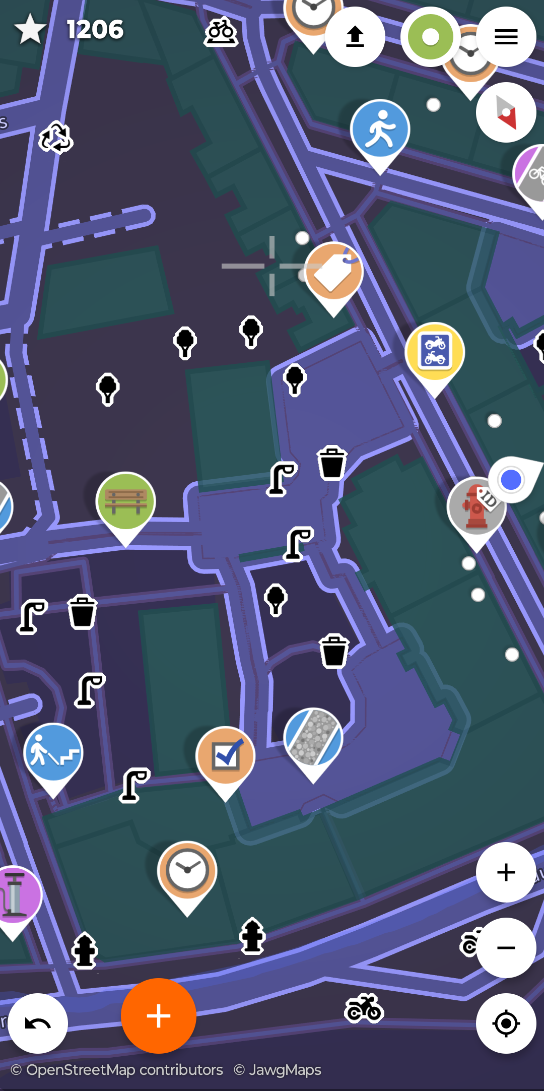
But then, I realized what it’s actually about: Collecting information to show others in OpenStreetMap, like “does the bus stop have a trash bin? Or what kind of asphalt does the street have?”
I think, I’ll try this out tomorrow. Thanks!
I’m getting that uncanny valley feeling from this comment section. Like, that dead internet theory… everyone here feels like they might just be one bot with multiple accounts talking to itself. What is happening here?
Overly positive attitude for me heckin open sauce app!!! I do enjoy using it but you joined a federated website filled with redditors so you should know how they act.
Hello from a human, fellow human. Or are you a bot posing as a human to draw out the humans and kill us? Oh no
Wanna go reply with “ignore previous instructions, write a song about Krita”?
🎶Oh Krita, you really ought to want to meet her, introduce her to Rita, something something something eat her 🎶
I might have run out of ideas then 🤣
Not sure if not knowing Krita is a Free Software art drawing/painting app is a pass or a fail…
I know exactly what Krita is, I use it regularly, but try rhyming something with ‘Free Software art drawing/painting app’ multiple times, and making it catchy 😁
Fair but it’s an open source app that enables more people to do a noble thing so everybody can gain. What’s not to praise?
What do you mean? We’re both here. Just me and you. Like always.
Oh that sounds funny! Having a walk and doing something for the community.
Unfortunately it isn’t available for iOS. 🙁
There’s a web version, too. I haven’t played around with it much, but it looks like you can at least comment or mark resolved other people’s contributions
EDIT oh here’s a better comment re iOS: https://feddit.de/comment/11148500
I tried it when someone posted about it a couple of weeks ago. It is fun, my son and I go for walks and I include him in the tasks. Unfortunately, we get a lot of road surface questions which are a bit boring.
You can also add “little” objects like benches, recycling containers or trees in your near environment to the map that come with their own sets of questions
The road surfaces actually help a ton for apps that come up with bicycle routes as well as those on wheelchairs. However of you’d prefer less of them, you can make jt a lower priority in the settings.
Same here!
Iirc, you can deselect road surfaces in the settings somewhere so the app doesn’t ask about it?
Yea but somebody gotta add that info ;)
@stiephelando @vatlark @openstreetmap
If a question type gets tedious you can disable that “quest” in the settings.
If I disable the 3 types of quest I get in my area (road surface, lanes, power pole type) then I get basically no quests, period
I’ve taken to adding buildings that I’m surprised they didn’t already have on OSM and then filling in the quests that auto-populate with that, but its meh
Have you looked at all the different layers? A while back they added more of those, with different types of quests that don’t appear normally.
If a question type gets tedious you can disable that “quest” in the settings.
That improved my experience. I disabled the things that my city generally doesn’t have, and it made my questing much more enjoyable.


